Rotorua Orienteering Club, NZ - Armchair O
Armchair Orienteering
A set of exercises you can do at home
to improve your navigation skills
When you go orienteering, how much time do you lose through navigational
errors? Would you like to reduce this time loss?
Often we spend several hours each week training our bodies to be able
to run faster, but we tend to neglect the mental side of our sport,
training it only when we go orienteering at the weekend. If you set aside
15 minutes a couple of times a week to do exercises to help the mental
side, you wll find your orienteering times improve rapidly.
Here's a few exercises to try. The only things you will need are a few
old maps, pens, paper and a table to work on. Each exercise will require a small amount of preparation. It is a good idea to do this several days in advance, so your mind forgets what
the map looked like. Alternatively, get a friend to do this bit for you.
1. Simplification
In orienteering you do not have to read every feature on the map, only the
ones which you need to get you to the next control. Simplification is the skill of being able to pick out those features,
usually the big ones, and using only them to navigate between controls.
By not reading every feature you will find yourself orienteering faster. This exercise helps you
practise simplification, and it will also improve your ability to interpret the map quickly and accurately.
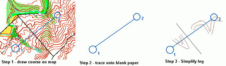
Preparation: Take an old map, and draw up a course on it. It doesn't really matter where
the course goes, but make all the legs around 5-6cm long (later you can use longer legs). Now take a blank
piece of paper, and trace the locations of the circles from your course.
Exercise: For each leg, study the map for a length of time. Start with
around 30 seconds per leg (use the countdown timer on your watch if it has one).
When you look at the map, look for the big features on the leg which would be easy to
navigate off. When the time is up, go to your blank course, and draw just these features
onto the map. Try not to look back at the original map while you are doing are this.
Don't be too precise - the idea is to simplify - so for a hill you might draw
a couple of circular contours.
Do this for each leg, and then review the course you have drawn on the new map. What
you should be trying to have is enough detail on your new map that you could use it
to roughly navigate your way to the control area. Not necessarily the
control site itself, but to the area around it.
As you practise this more, try reducing the time you spend looking at each leg. If the map is a local map, you could try
going out and running the course using your simplified map to do the bulk of the navigating. This will show
you whether or not you are simplifying the right details.
2. Visualisation (part 1)
The ability to look at a map, and then convert this into an image in your mind of how it will look on the ground is very important in orienteering. Then when you run into an area, you will already know what it should look like, and if this image is correct, it should match the landscape in front of you.
Practising this skill will help you to:
- Learn to do it faster
- Learn to do it more accurately
- Learn to do it for a larger map area
- Learn to to it on more complex maps
Preparation: On your old map, draw a number of circles, as shown on the map below. Try drawing about 10 circles on the first map, each about 1 - 1.5cm across.
Exercise:  Now look at each circle in turn. Try to imagine how this will
look in the forest. For example if the circle is on a small
hill, imagine exactly how the hill will look. If there is a track
next to it, try and see this as well. Spend about 30-40 seconds on each circle,
then move on to the next one.
Now look at each circle in turn. Try to imagine how this will
look in the forest. For example if the circle is on a small
hill, imagine exactly how the hill will look. If there is a track
next to it, try and see this as well. Spend about 30-40 seconds on each circle,
then move on to the next one.
As you get better at this, try using a timer to limit how long you
have to look at each circle. Try increasing the size of the circle
slightly (but not too big, or it will just become too complex). Try
using a more complex map, maybe start with a local farm, and move
onto a detailed forest area. Try visualising the same circle from 2 different directions (as
if you were standing on both sides of the circle).
At your next orienteering event, try linking
these two exercises together. At the start of each leg, simplify it.
Run the leg using just the big features you have picked out. Because
you are navigating off the bigger features, you should find that while you are running
you have time to look at the control circle, and the area just around
it. Visualise how this area will look. If you have been practising this at home
then this should be relatively easy. Work out where the control will
be in this area. Then when you get to the control circle, what you are
seeing should match your mental image, so you should be able to
just run in and clip the control.
Sounds easy, but it will happen.
3. Visualisation (part 2)
This exercise is a more advanced visualisation. It is similar to the
previous exercise, but instead of concentrating on just a small area,
you visualise the terrain along a leg on a course. Make sure you are
comfortable being able to visualise the terrain in the previous exercise
before you move on to this exercise.
Preparation: For this exercise you will need a course drawn on a
map. Any course will do, as long as it's not one you've run on before.
Exercise: Take each leg in turn, and imagine your way through the
course. Imagine you run to the start triangle and pick up the map. Plan
your route to the first control. Now pretend you are running this chosen
route. What techniques do you use (e.g. compass bearing)? What do you
see along the way?
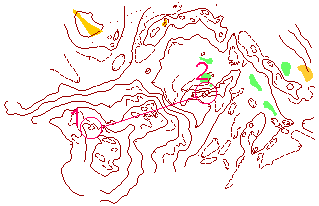 Have a look at the following example leg.
When you are visualising the route from 1 to 2, you should imagine yourself
leaving the knoll at control one, and running along the left hand edge of
the large ridge which runs under the red line. Think about how it might
look on your right. Then you run up on to it, and through the detailed area.
Think of how this will look, and then imagine yourself running down the
steeper slope (the 3 contours close together). Now imagine yourself running
along the edge of the small ridge the control is on, and then running up to
clip the control. Have a look at the following example leg.
When you are visualising the route from 1 to 2, you should imagine yourself
leaving the knoll at control one, and running along the left hand edge of
the large ridge which runs under the red line. Think about how it might
look on your right. Then you run up on to it, and through the detailed area.
Think of how this will look, and then imagine yourself running down the
steeper slope (the 3 contours close together). Now imagine yourself running
along the edge of the small ridge the control is on, and then running up to
clip the control.
There is no need to shut your eyes, just think about how the ground
will look. Remember to always visualise yourself spiking the control.
If you use techniques when you are orienteering such as planning ahead, then you
could incorporate this into the exercise by pretending to plan ahead during
the easier parts of the course.
This exercise will help you in several ways.
- It helps improve your map interpretation
- It helps you practise doing a complete course, selecting techniques
where appropriate, without having to actually go and run the course
- In an actual event, before you get to an area on the map, it helps to know
what it will look like. This exercise practises that skill.
If you do a programme of stretching your muscles, this is something you can do
while you are stretching. It will help to make it more interesting. You can also practise it on a
normal training run if you want, which will help your map reading.
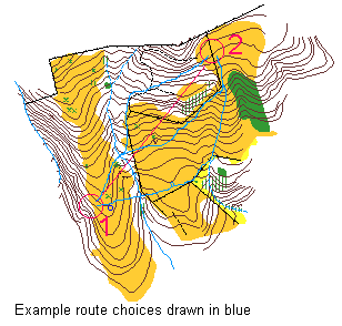
4. Route Choice
If you have problems with selecting the correct route to use on a leg, this
exercise may be of some help. It works on the two main components of route
choice: identifying alternative routes, and evaluating which is the best
Preparation: For this you will need a course planned out on a map.
The legs do not have to be planned specifically for route choice, however
it will help if they are reasonably long (6cm - 10cm). It is OK to use a
course you have run on before.
Exercise: Using a timer set for around 30-45 seconds, look at each leg
in turn. For each leg, draw on to the map at least 3 separate route choices (this is
why you don't want short legs, where usually the only route is to go straight).
Don't worry at this stage about which is the best route - the important skill
here is to be able to identify possible route choices.
 - Once you have been through the course identifying all the possible route choices,
work through each leg again. This time around give yourself around 30-45 seconds to
evaluate which route choice is the best on each leg. This will improve your
ability to evaluate the route choices. Obviously you can't actually go out
and run the legs to check if your choice is correct. However the important
thing is to be practising evaluating the trade offs between
- distance travelled
- height climbed
- ease of navigation / ability to plan ahead during the leg
- type of terrain you are running through - green or white?
When you select the map for this, remember that in general hilly maps, or
maps with lots of green, are harder to select route choices on. So maybe
save these for when you have practised this a few times. Also as you get
better, give yourself less time to make the decisions on what routes are possible,
and also which routes are the best.
|
